The Sun, San Francisco, and The Photographer's Ephemeris
|
|
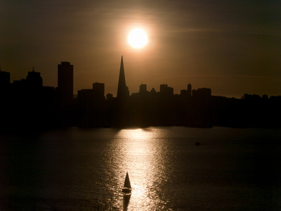
This image shows the San Francisco skyline, silhouetted as the late afternoon sun was passing over the skyline's iconic feature, the Transamerica Building. My vantage point for this shot was on Yerba Buena Island in San Francisco Bay. Wasn't that a lucky time and place to have my camera ready...or, was it really all a matter of "luck"? Certainly, the boat sailing into the center foreground was a piece of luck; but luck didn't account for the fact that I happened to be standing at that time and that place with a camera and tripod. The composition in this shot, i.e., the setting sun close behind the Transamerica Building--timed down to the minute--was actually planned some weeks earlier (while I was at home on the opposite side of the continent). This was made possible by software called "The Photographer's Ephemeris" (TPE). TPE is a program with a single purpose. It enables any landscape photographer to visualize "if, when and how" the sun and moon might appear within (or place illumination upon) a prospective scene. It manages to do this quite cleverly using a single window (shown at left). The interface has two interrelated sections: a zoomable, browsable map and a table showing numerical and graphed 'ephemeris details'. TPE's map and tabular data provide you with knowledge of the sun and moon positions (azimuths and altitudes) correlated to any location, date and time of interest. |

|
TPE 'Ephemeris Details' TableFirst, I decided to consider tiny Yerba Buena Island (in San Francisco Bay) as a potential viewpoint. It is easily reached by ramps located near the midpoint of the SF-Oakland Bay Bridge, and it provides opportunities for close-up, unobstructed west-facing views of San Francisco. I'd been there briefly once before-- about 15 years ago. Then I decided to use TPE to determine if anything "interesting" (in regard to sun or moon positions) would occur during the week of my visit. Specifically, I wondered exactly where the sun would be setting (vis-a-vis the SF skyline). For example, might there be a "close encounter" between the sun and the prominent Transamerica pyramid? Well, it turned out that I did have some luck there! The screenshot (at left) shows the part of TPE's window that presents the sun and moon ephemeris (position data). The date (January 15, 2011) was during the week that I'd be visiting with my daughter and her family, who live in the SF Bay Area. During that visit I hoped to have an opportunity for some local landscape photography (weather permitting). At the top of the window are the 'official' event times for sunrise/sunset and moonrise/moonset; also the azimuth values (directions) at which these occur. Oh, and it tells you the moon's phase, too. To begin with, you must select a viewpoint (your camera's location) on TPE's map; then all the tabular data and the map direction-indicators are corrected automatically to be in accord with that location. Although you must start out by making a choice about where to stand for your photograph, this placement can easily be adjusted at any time. As mentioned, I was interested in shooting from a location on Yerba Buena Island. Further down on the data table is a color-coded graph of sun and moon altitudes as they change during this particular 24-hour period; any specific time-of-day (TOD) can be quickly reached by moving a slider. As the time-slider is moved, the area below the graph updates to show the selected hour:minute and the corresponding positions (azimuths and altitudes) of sun and moon. Also, as the TOD is changed, a set of indicator lines on the map automatically rotates to show the sun & moon movements. This is described in more detail below. |
|
|
TPE Map SectionIn the next screenshots (left and below) we see how some of the ephemeris data, i.e., the azimuth values, are overlaid on TPE map. TPE provides a red location-marker (balloon) that can be dragged to any position on the map to indicate the camera's viewpoint, and any of your locations can be assigned a name and saved for later use. In the screenshots, I've shown the red balloon placed on Yerba Buena Island. The map can be zoomed to allow fairly precise positioning; I've select a spot between some buildings which offered a clear view to the skyline across the bay. My selected spot is about 200 feet above sea level and also close to a fairly steep drop-off. [Note: By carefully examining the terrain details using the map's 'Terrain' mode you might avoid unpleasant surprises when you actually attempt to reach your desired "spot".] The directions (azimuths) for sunrise and sunset events are indicated by thick, colored lines of pale-orange and dark-orange, respectively. The moonrise and moonset azimuths are indicated by thick lines of pale-blue and dark-blue, respectively. For any times of day between the fixed risings and settings, the movements of sun and moon are shown by thin lines of orange and blue, respectively. As the TOD slider is moved, these thin lines sweep about their origin (red marker)--following the sun and moon positions. |
|
If the red marker is dragged to a different position, TPE immediately adjusts all the color-coded indicators to reflect the changed viewpoint. Thus you can 'fine tune' your camera position by observing how a move affects the azimuth lines (which of course are "sight lines" towards the sun and moon). TPE also provides a movable, gray marker balloon (in screenshot at right) which you can place on any map spot to focus attention on a specific feature in your composition. For me, that "spot" was the Transamerica Building. In the example below I've placed the gray marker as close as possible (aided by zooming) to the center of the Transamerica building. Note that TPE always draws a thin, gray line connecting the red and gray balloons. At the bottom of the data window are several useful details about the gray balloon location: the distance (2.06 mi.), altitude (-0.4 degree) and elevation change (-72 ft) all relative to my position (i.e., red balloon) . The thick, dark-orange indicator told me that sunset would occur not too far away (just 5 or 6 degrees of azimuth) from the pyramid's bearing, so the sun would be fairly low when it passes that location. To determine exactly when the sun would arrive at the pyramid, I moved the TOD slider carefully so as to cause the thin orange indicator to align exactly with the gray marker (line). That time of day was shown as 16:41 hours. In other words, at about 4:41 PM (+/- 5 minutes) the sun will just be passing the Transamerica pyramid...and the sun altitude would be 5.1 degrees. I hoped to shoot the scene with the sun passing very close to the peak of Transamerica Building. Ideally (IMHO), the sun would appear to touch the 850-foot tall pyramid. If, for my selected viewpoint+ date + time, TPE tells that the sun would be at 5.1 degrees of altitude, then how does that compare to the apparent altitude of Transamerica's peak? Well, the gray-marker data states that the distance to Transamerica is 2.06 miles; the building's base is 72 feet below my position on Yerba Buena and that corresponds to -0.4 degrees (i.e., a 0.4 degree drop in altitude). I roughly estimated (too roughly, perhaps?) that the sun's disc should come close to "hitting" the Transamerica 850 ft.-tall peak. |
|


|
I arrived on location in plenty of time to set up my equipment and shoot the scene on January 15, 2011. The sun actually passed directly over Transamerica at about 4:36 PM. However it seemed to me that the sun was passing somewhat farther (higher) above the tip of the "Pyramid" than I'd expected. After the shoot, I repeated (with more care) my calculation of the Transamerica's (apparent) altitude, and I discovered that it was actually close to a full a degree lower than I'd been "guesstimating". So the "close encounter" with the sun turned out not quite as close as I'd expected. The error was mine, not TPE's (TPE was right on target with the sun's position). The lesson learned here was that if the composition contains a prominent object that is "natural" (e.g., a hill or mountain) then TPE can provide fairly accurate elevation data; but when dealing with any sizable man-made object (e.g., a bridge, building,...) the user is responsible to estimate accurately (emphasis on accurately) the object's apparent altitude/elevation. In spite of my miscalculation, I'm fairly well-pleased with the results of my photography that afternoon. And I'm certainly pleased with The Photographer's Ephemeris. My thanks go to the author of The Photographer's Ephemeris, Stephen Trainor (http://stephentrainor.com/tools), for distributing the desktop version of TPE as freeware (for Macintosh and Windows). Recently his iPhone/iPad version of TPE became available. Check it out. In my opinion, TPE is a very "cool tool" that no landscape photographer should be without. Back to my Views from Yerba Buena gallery |