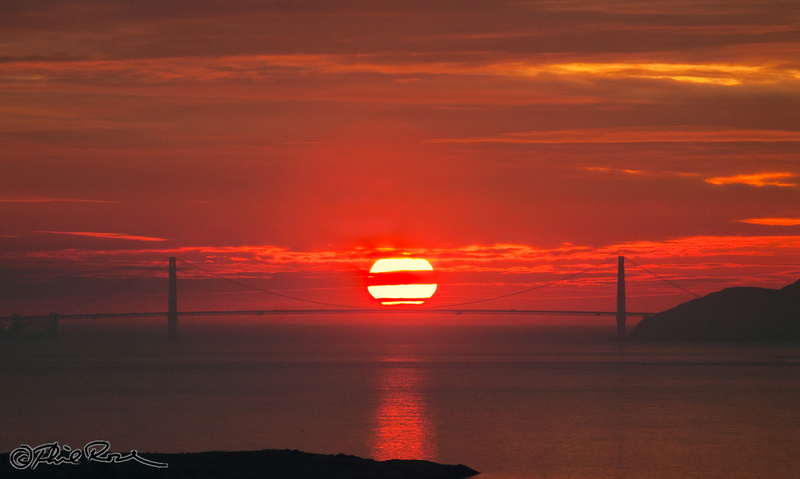
 Sunset on The Golden Gate (view from Indian Rock))
Quest for a Centered Golden Gate Sunset
Phil Rose
March, 2013
During a visit to the SF Bay Area in Spring of 2012 I became aware of a local landmark in the Berkeley Hills–a granite outcropping called "Indian Rock". Its elevation above the surrounding neighborhood allows an unobstructed view out over the bay toward the Golden Gate Bridge, which is about 12 miles away. I had recently seen an image (photographed from that same spot) in which Hal Davis, a well-known Berkeley photographer, had captured the setting sun as it passed across the very center of the bridge span. I soon became intrigued with the idea of photographing my own Golden Gate sunset from the Indian Rock location. I hoped that Hal, who'd been my instructor in a photography workshop not long ago, would regard my imitating his "centered" sunset as just an attempt at sincere flattery. So I decided to try for my own version.
I was drawn by the technical challenge of capturing the sun at the moment of its "touching" the bridge deck and also by the visual appeal of the sun's disk being held in the graceful catenary arc of the suspension cables. However I did not have high hopes of achieving this goal after I realized that such a shot (from Indian Rock) was possible for only a couple of days each year, occurring sometime in late January to early February. In that limited range of days, the sun's seasonal movement causes the sunset to occur about midway between the two towers of the Golden Gate (when viewed from cerain locations east of the bridge). Now, although I did live east of the Golden Gate, it was at a rather inconvenient distance (in NY State). However as luck would have it, we found ourselves planning a visit our family in the the East Bay during the latter part of January, 2013. This trip was motivated by our granddaughter's 16th birthday and also my wife and daughter's planned attendance at a retreat (Buddhist vegetarian, of course) in Santa Cruz.
Would there be an possibility for some solar serendipity? [ Spoiler Alert: Yes, the sun was cooperative! If you're impatient to see a result and don't care for all the gory details, please just skip to the bottom.]
I had some experience using a particular software tool which I knew would be invaluable when I started considering this shot; it 's a program called
"The Photographer's Ephemeris" (TPE is available for Mac, Windows and iOS/Android mobile devices). It provides easily understandable information showing the positions of the sun and moon relative to any location and for any selected date and time. In
another article I describe in some detail how I'd used TPE to plan for another "shoot into the sun". That previous shoot was from Yerba Buena Island–looking across the Bay to San Francisco; my images showed the sun passing close to the top of the Transamerica Pyramid Building.
Anyway, a month or two before our January visit, I was pleasantly surprised when I used TPE to "explore" the ephemeris for late January, 2013. TPE showed that our visit would overlap with those few "special" mid-Golden-Gate sunsets. TPE also led me to deduce that the dates of January 23, 24, and 25 would offer the best chances for that centered shot. That was because the sunset azimuths (directions) for those particular days occurred just very slightly beyond (i.e., to the right or north of ) the midpoint of the Golden Gate span as seen from Indian Rock. That situation is a prerequisite, since the sun's azimuth is gradually moving slightly northward as it drops toward the horizon at sunset. Consequently, at a few minutes before sunset–when the sun's altitude is still high enough to make it seem to "rest" on the bridge deck–it might (with some luck) also appear near the very middle of the bridge span. With...some...luck.
While I haven't (yet) had experience shooting a Golden Gate sunset from elsewhere than Indian Rock, I'll mention that numerous other locations in the East Bay (mostly near sea level along the bay shore) appear suitable for attempts at shooting a "centered" sunset shot on other days of the year (mid-October to late February). So no need for us out-of-towners to be restricted to January.
Figure 1 illustrates TPE's graphical interface. Here our virtual (camera) location is on Indian Rock, looking out toward the Golden Gate on Jan. 24). I've placed the red
primary location marker atop Indian Rock
(at upper right). TPE causes three orange-colored azimuth lines to emanate from that marker to show the sun's bearings at different times of day (two fixed lines indicate sunrise and sunset and the third, variable one, is for any specified time set with a time-of-day slider). Similar azimuth lines (colored blue-gray) are also shown for the moon positions. I placed the
secondary (gray) location marker at my anticipated target–i.e., at the center of the Golden Gate Bridge (lower left); that location could be accurately identified using TPE's
zoomed-in satellite view.
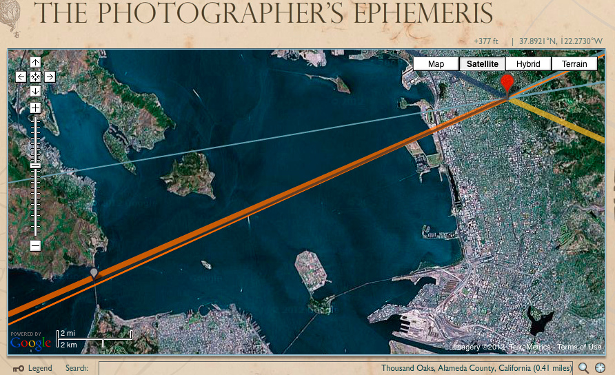
Figure 1. The thick orange line is the direction of the sunset; the thin, orange line shows the sun's time-dependent azimuth. Keeping track of the latter helps the photographer visualize the sun location within the scene or, perhaps simply its effect on scene lighting. In this example the time-of-day has been set to about five minutes before sunset.
|
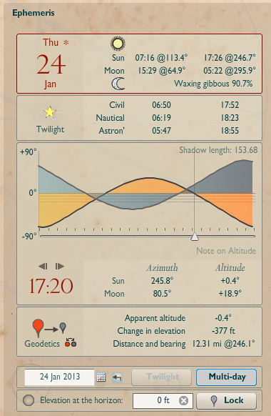
Figure 2. TPE ephemeris data and time-of-day slider
|
Fig. 2 shows four sections of ephemeris information for Jan. 24, 2013 (any calendar date can be selected); the time-slider, in the third section, is adjustable in one-minute increments; and as the time is changed, TPE immediately shows (graphically and numerically) corresponding changes in ephemeris (e.g., the sun's azimuth in degrees and its altitude–also in degrees). For planning my shot, the azimuth is just one of the two coordinates I need in order to specify the sun's position in the scene. That required azimuth is established graphically (in Fig. 1), after adjusting the time of day by trial and error. The other required coordinate is the sun's apparent altitude–and for the "effect" I'm aiming to get–I will actually need to know (for the selected time of day) the sun's altitude relative to the bridge deck. That means I also will need to know the apparent altitude of the bridge deck relative to my primary location, Indian Rock.
The bottom (fourth) data section in Fig. 2 contains various information (apparent altitude, change in elevation, distance, etc.) relative to our secondary location marker. So what about the that value "Apparent altitude" (-0.4); does that tell us the (apparent) altitude of the bridge deck? Unfortunately, No. It would be great if TPE could generate the apparent altitude of the Bridge deck. Come on, didn't we place that secondary location marker on the deck? Well, in reality, while the marker seems to be on the bridge, it actually is considered by TPE as being placed on the natural terrain lying beneath the bridge (in this case, that means the SF Bay, or sea level).
|
The Bridge structure is a man-made thing that is essentially "non-existent" in TPE's calculations of altitude since the heights of many (most?) man-made structures are not available to TPE–just the terrain elevation on which they stand. Perhaps some future version of TPE might be able to calculate apparent height of such structures from user-provided height? Anyway, the final step needed in order to anticipate how the sun or moon will appear in relation to most high, man-made objects must be based on some separate estimating done by the user (i.e., outside of TPE). Fortunately we only need to know the value for the bridge deck height. And then some pretty straightforward trigonometry (really, just arctangents).
According to Bridge specifications found online, the G-G deck height is 220 feet above sea level. TPE shows that Indian Rock has an elevation of 377 ft above sea level and its distance to the G-G is 12.3 miles; sea level just below G-G Bridge has an apparent altitude of -0.4 degree; finally, the horizon is 24 miles away with an apparent altitude of -0.3 degree. Without going into details of the basic trig involved, I estimated that seen from Indian Rock, the Bridge's 220 ft-high deck has an apparent altitude of about -0.14 degree. That means the deck appears to be about 0.1 to 0.2 degree above the horizon. So whenever the center of the sun reaches an apparent altitude of roughly +0.4 degree (above the horizon), the bottom edge of its disc ought to just "touch" the bridge deck [using the fact that the sun's disc has an apparent diameter of about 0.5 degree]. A lot of approximations and rounding errors, but...
According to TPE, the "touching moment" would happen at about 5:20 PM, or about 5 or 6 minutes before civil sunset (i.e., sunset time is automatically corrected for Indian Rock elevation). For that time of day TPE indicates the sun's azimuth line approaches very near to the span midpoint! So I became optimistic that this shoot was well worth a try. However, considering the inaccuracies inherent in my estimates (e.g., uncertainty due to issues such as refraction, parallax, rounding errors, etc.), I realized it was not a sure thing that the sun would exactly "hit the mark" as perfectly as I hoped. Of course the idea is to take many shots at short intervals and hope one is "right".
I couldn't attempt the shot on January 25th because of another commitment, and January 23rd turned out to be overcast and even drizzling rain late in the day, so no attempt was made then. The last possibility would be the 24th; so despite the very heavy overcast we (I and daughter, Jen) decided to head out to Indian Rock. Braving the rush-hour traffic we reached it shortly before 5 PM, and I was able to scale the Rock–keeping camera, tripod and my septuagenarian body intact. I had everything set up to shoot in a matter of a few minutes. I anticipated a crowd, but happily just one other photographer was there, and he had positioned himself at quite a distance from--and about 10 or 12 feet directly below--the spot I wanted to use, so no problems in that regard. But the gloomy, sunless twilight made it barely possible to see the bridge for focusing (perhaps a reason for the low attendance). This was definitely a situation requiring careful manual focus since merely setting the lens at "infinity" was likely to produce OOF shots. Anyway, about 10 minutes before sunset (not much time to spare, huh?) the sun started to peek out from beneath the low-hanging cloud cover (see photo at the top of this article). Eventually it broke into nearly full view (but never quite full) and created a pretty nice display of glowing color as it slid past the Golden Gate Bridge and finally dipped below the horizon.
Among my shots from that afternoon, the one shown at the top of this page has the sun appearing to "hit the deck"; the illusion is aided somewhat by atmospheric refraction. Old Sol managed to be nearly centered though very slightly offset to the right, but I was happy with this result–especially for a first try. I kept shooting for a few more minutes...until sunset, but we had an early dinner/show reservation and needed to race back toward Oakland in time to join our spouses at the restaurant. All in all, this turned out to be a successful, although stressful, photographic evening. My "Golden Gate Sunset"
gallery contains a number of images made during this special sunset. They are shown below in an animated gif:
